 Statybinės medžiagos
 Metalai
 Tvoros, vartai
 Įrankiai ir įrengimai
 Šildymas, santechnika
 Sodo, daržo prekės
 Baldai
 Buitinė technika ir elektronika
 Kvepalai ir kosmetika
 Laisvalaikis, sportas, turizmas
 Prekės vaikams
 Laikrodžiai, dovanos, suvenyrai
 Medicina, sveikata
 Sekso prekės
+370 650 05879
info@b-a.eu
(I-V 8:00 - 16:00)
Navigacija Garmin Nuvi 2569LMT-D West-Europe
Prekės kodas
310820201181


Pateiktos prekių nuotraukos gali skirtis nuo užsakytos prekės. Nuotraukoje gali būti priedų, lipdukų ar kitų detalių, kurių nėra prekės komplektacijoje.
Dėl Jūsų įrenginio nustatymų ekrane matoma prekės spalva gali skirtis nuo realios prekės spalvos.
Matavimo vienetas:1 vnt
Buvusi kaina:
162.81 €
Prekė yra išparduota. Šiuo metu jos nėra nei mūsų, nei mūsų tiekėjo sandėliuose.
Atsiėmimas iš sandėlio
2.90 €
Pristatymas į namus
3.45 €
Pristatymas į pašto skyrių
2.70 €
"LP Express 24" paštomatas
1.90 €
"Omniva" paštomatas
2.60 €
Perkant prekes www.b-a.eu elektroninėje parduotuvėje, už įvykdytus užsakymus galite
gauti lojalumo eurus, kuriuos galėsite panaudoti kaip nuolaidą savo sekančiams užsakymui. Skaitykite plačiau.
info@b-a.eu
+370 650 05879
Advanced GPS Car Navigation
- 5.0-inch pinch-to-zoom, dual-orientation display
- Detailed regional maps of Europe with free lifetime¹ map updates and digital traffic², the best traffic avoidance solution available from Garmin
- Find new and popular restaurants, shops and more with Foursquare®
- Bluetooth® technology for hands-free calling³
Bright Display
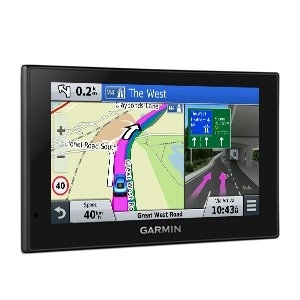
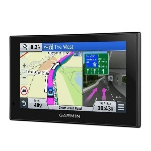
nüvi 2569LMT-D has a bright 5.0-inch display with pinch-to-zoom capability, so you can quickly get a closer look at any onscreen information. Dual-orientation allows you to use nüvi 2569LMT-D either horizontally or vertically.
Detailed Maps with Free Updates
nüvi 2569LMT-D arrives loaded with detailed regional maps of Europe. With free lifetime¹ map updates, your routes are sure to reflect the most up-to-date maps, points of interest (POI) and navigation information available. New maps are available for download for the useful life of your GPS device, with no fees.
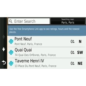
Foursquare Adds Millions of New POIs
With so much data, nüvi 2569LMT-D makes it easy to find addresses and millions of POI – that is, businesses, stores, restaurants or other destinations. Our POI database also includes accurate, relevant information sourced from Foursquare. Now, when you search, the most relevant Foursquare result appears at the top of the list. It’s an easy way to discover new and popular restaurants, shops and more.
When you use the Smartphone Link app with your nüvi 2569LMT-D, you can also check-in on Foursquare and access more detailed information about the POI, including ratings, price range and hours of service.
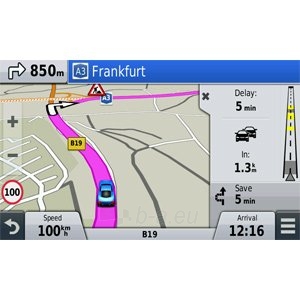
The Best of Our Traffic Solutions
Digital Traffic is the best traffic solution available from Garmin. Digital Traffic is fast and free² – no distracting advertising and no subscription fees, ever, for the useful life of your device. Plus, Digital Traffic has a great coverage area that includes interstates, highways and secondary roads.
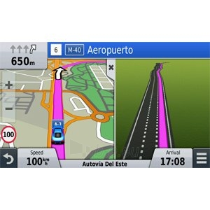
On the nüvi 2569LMT-D, traffic alerts appear to the side of your map, so your driving map remains onscreen. Traffic messages are spoken, too. Digital Traffic is voice-activated, so it responds to spoken requests. It can give details about the situation, such as how many minutes of delay to expect and if there are any possible detours. Digital Traffic can even confirm whether or not you are on the fastest route. Plus, traffic information is delivered straight to your nüvi – no smartphone needed.
Garmin Real Directions™
Drive with confidence, even when you’re out of cell phone range. nüvi 2569LMT-D is dedicated automotive navigation that does not rely on cellular signals and is unaffected by cellular dead zones.
nüvi 2569LMT-D redefines “spoken turn-by-turn directions” with Garmin Real Directions, easy-to-understand driving directions that guide like a friend, using recognizable landmarks, buildings and traffic lights. No more stress from trying to read street names. Instead, hear clearly spoken guidance, like “Turn left after the gas station.”
Find Exactly Where You Need to Go
The Direct Access feature simplifies navigating to select complex destinations, like airports and shopping malls, by finding a place within a larger location. When navigating to the mall, Direct Access gives additional location information for specific retail stores inside. For example, "Arriving at Woodfield Mall. Anthropologie is inside, on the upper level." Direct Access even navigates through parking lots to find the entrance nearest your destination.
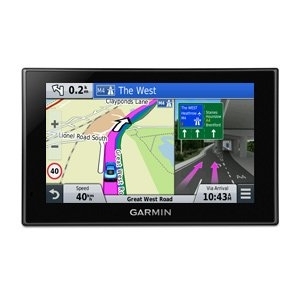
Easily Navigate Complex Interchanges
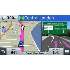
Active Lane Guidance with voice prompts prepares you to drive through an exit or interchange with confidence. As you approach, an animated model uses brightly colored arrows to indicate the proper lane needed for your route; a friendly voice offers additional help. Bird’s Eye junction view offers a detailed view of interchanges, looking down as if from overhead. photoReal Junction View realistically displays junctions and interchanges along your route, including the surrounding landscape. Brightly colored arrows indicate the proper lane to drive. nüvi 2569LMT-D also depicts real road signs as they appear along your route.
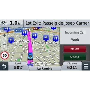
Bluetooth® Compatible
Sync a Bluetooth-enabled device³, such as your smartphone, to nüvi 2569LMT-D for hands-free calling through its integrated microphone and speaker. Stow your phone in your pocket, purse or console and still make and take calls.
Smartphone Link Compatible
Smartphone Link is a free mobile app that connects your nüvi 2569LMT-D with your iPhone® or Android™ smartphone. When paired, your nüvi can use your phone’s existing data plan4 to share information – such as where you parked, POIs and your destination. With the Smartphone Link app, you can conveniently send locations and addresses from your phone straight to your nüvi.
Smartphone Link also gives you access to Garmin Live Services5, useful real-time information such as weather. Smartphone Link works with iPhone 4S or later and some Android devices.
More Information At a Glance
nüvi 2569LMT-D keeps your driving map onscreen at all times and additional information appears alongside. For details, simply touch the screen. As you drive your route, Up Ahead constantly informs you of nearby services, including food, fuel and ATMs.
nüvi 2569LMT-D displays speed limit, current speed and estimated time of arrival. With a quick glance, you can read the name of your current street. nüvi 2569LMT-D also provides school zone alerts.
- 5.0-inch pinch-to-zoom, dual-orientation display
- Detailed regional maps of Europe with free lifetime¹ map updates and digital traffic², the best traffic avoidance solution available from Garmin
- Find new and popular restaurants, shops and more with Foursquare®
- Bluetooth® technology for hands-free calling³
Bright Display
nüvi 2569LMT-D has a bright 5.0-inch display with pinch-to-zoom capability, so you can quickly get a closer look at any onscreen information. Dual-orientation allows you to use nüvi 2569LMT-D either horizontally or vertically.
Detailed Maps with Free Updates
nüvi 2569LMT-D arrives loaded with detailed regional maps of Europe. With free lifetime¹ map updates, your routes are sure to reflect the most up-to-date maps, points of interest (POI) and navigation information available. New maps are available for download for the useful life of your GPS device, with no fees.
Foursquare Adds Millions of New POIs
With so much data, nüvi 2569LMT-D makes it easy to find addresses and millions of POI – that is, businesses, stores, restaurants or other destinations. Our POI database also includes accurate, relevant information sourced from Foursquare. Now, when you search, the most relevant Foursquare result appears at the top of the list. It’s an easy way to discover new and popular restaurants, shops and more.
When you use the Smartphone Link app with your nüvi 2569LMT-D, you can also check-in on Foursquare and access more detailed information about the POI, including ratings, price range and hours of service.
The Best of Our Traffic Solutions
Digital Traffic is the best traffic solution available from Garmin. Digital Traffic is fast and free² – no distracting advertising and no subscription fees, ever, for the useful life of your device. Plus, Digital Traffic has a great coverage area that includes interstates, highways and secondary roads.
On the nüvi 2569LMT-D, traffic alerts appear to the side of your map, so your driving map remains onscreen. Traffic messages are spoken, too. Digital Traffic is voice-activated, so it responds to spoken requests. It can give details about the situation, such as how many minutes of delay to expect and if there are any possible detours. Digital Traffic can even confirm whether or not you are on the fastest route. Plus, traffic information is delivered straight to your nüvi – no smartphone needed.
Garmin Real Directions™
Drive with confidence, even when you’re out of cell phone range. nüvi 2569LMT-D is dedicated automotive navigation that does not rely on cellular signals and is unaffected by cellular dead zones.
nüvi 2569LMT-D redefines “spoken turn-by-turn directions” with Garmin Real Directions, easy-to-understand driving directions that guide like a friend, using recognizable landmarks, buildings and traffic lights. No more stress from trying to read street names. Instead, hear clearly spoken guidance, like “Turn left after the gas station.”
Find Exactly Where You Need to Go
The Direct Access feature simplifies navigating to select complex destinations, like airports and shopping malls, by finding a place within a larger location. When navigating to the mall, Direct Access gives additional location information for specific retail stores inside. For example, "Arriving at Woodfield Mall. Anthropologie is inside, on the upper level." Direct Access even navigates through parking lots to find the entrance nearest your destination.
Easily Navigate Complex Interchanges
Active Lane Guidance with voice prompts prepares you to drive through an exit or interchange with confidence. As you approach, an animated model uses brightly colored arrows to indicate the proper lane needed for your route; a friendly voice offers additional help. Bird’s Eye junction view offers a detailed view of interchanges, looking down as if from overhead. photoReal Junction View realistically displays junctions and interchanges along your route, including the surrounding landscape. Brightly colored arrows indicate the proper lane to drive. nüvi 2569LMT-D also depicts real road signs as they appear along your route.
Bluetooth® Compatible
Sync a Bluetooth-enabled device³, such as your smartphone, to nüvi 2569LMT-D for hands-free calling through its integrated microphone and speaker. Stow your phone in your pocket, purse or console and still make and take calls.
Smartphone Link Compatible
Smartphone Link is a free mobile app that connects your nüvi 2569LMT-D with your iPhone® or Android™ smartphone. When paired, your nüvi can use your phone’s existing data plan4 to share information – such as where you parked, POIs and your destination. With the Smartphone Link app, you can conveniently send locations and addresses from your phone straight to your nüvi.
Smartphone Link also gives you access to Garmin Live Services5, useful real-time information such as weather. Smartphone Link works with iPhone 4S or later and some Android devices.
More Information At a Glance
nüvi 2569LMT-D keeps your driving map onscreen at all times and additional information appears alongside. For details, simply touch the screen. As you drive your route, Up Ahead constantly informs you of nearby services, including food, fuel and ATMs.
nüvi 2569LMT-D displays speed limit, current speed and estimated time of arrival. With a quick glance, you can read the name of your current street. nüvi 2569LMT-D also provides school zone alerts.
| GPS type | |
|---|---|
| Marine (chartplotters, sounders): | N |
| Auto: | Y |
| Sport (fitness, running): | N |
| Outdoor (hiking, trekking): | N |
| Geocaching (GPS stash hunt): | N |
| Aviation: | N |
| Bicycle: | N |
| Truck: | N |
| Camper/Caravan: | N |
| Golf: | N |
| Navigation | |
| Traffic Message Channel (TMC): | Y |
| Lane guidance: | Y |
| Route avoidance: | Y |
| Number of waypoints: | 1000 |
| Speed limits: | Y |
| Waypoints: | Y |
| Tracklog: | Y |
| 3D landmarks: | N |
| Photo navigation: | N |
| Spoken street names: | Y |
| Map | |
| Maps included: | Y |
| Map coverage: | Western Europe |
| Ability to add maps: | Y |
| Display | |
| Touchscreen: | Y |
| Display: | TFT |
| Display diagonal: | 12.7 cm (5") |
| Display resolution: | 480 x 272 pixels |
| Display size (HxV) (imperial): | 63.5 x 111.8 mm (2.5 x 4.4") |
| Memory | |
| Compatible memory cards: | MicroSD (TransFlash) |
| Storage media type: | SSD |
| Networking | |
| Bluetooth: | Y |
| Design | |
| Form factor: | Handheld/Fixed |
| Colour of product: | Black |
| Interface type: | Touch Screen |
| Weight & dimensions | |
| Height: | 84 mm |
| Weight: | 184 g |
| Width: | 138 mm |
| Depth: | 18 mm |
| Performance | |
| Built-in speaker(s): | Y |
| Number of built-in speakers: | 1 |
| MP3-player: | N |
| Anti-theft function: | N |
| Power | |
| Power source type: | Battery |
| Battery technology: | Lithium-Ion (Li-Ion) |
Prekės charakteristikos
- Prekės kodas 310820201181
- Gamintojas GARMIN
- Preliminarus prekės tiekimo terminas (d.d.) 2-4 d.
Komentarai
Taip pat siūlome


